Reading the Okavango Delta Botswana map for luxury trip planning
The Okavango Delta Botswana map is the starting point for any refined safari itinerary. When you understand how the delta, channels, and islands relate to each other, you can match specific camps and activities to your travel style. This level of planning matters even more for premium travellers who value privacy, seamless logistics, and meaningful wildlife encounters.
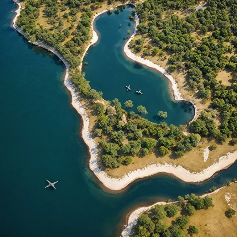
On a detailed delta map you will see the Okavango River fanning into a labyrinth of water and land that covers between 15 000 and 22 000 km². This inland delta in the Kalahari Desert appears as a mosaic of permanent swamp, seasonal floodplains, and drier sandveld, and each area supports different wildlife and safari experiences. Reading these map details carefully helps you choose where to focus your time for big game, birdlife, or water based activities.
Most travellers fly into Maun, the gateway town on the southern edge of the Okavango, before connecting by light aircraft to a private concession or game reserve. On any good Okavango Delta Botswana map Maun sits just outside the main wetland, yet its position is crucial for understanding flight routes and transfer times. When you compare distances between Maun, Moremi Game Reserve, and the central delta area, you can balance travel time with the number of nights in each camp.
The Okavango River itself rises in Angola, then flows through Namibia before finally spilling into Botswana as a vast inland fan. On a map Okavango channels appear as blue arteries feeding lagoons, backwaters, and floodplains that sustain some of Africa’s most concentrated wildlife. A precise delta map will also show how seasonal water levels shift, which is essential when choosing between water focused or land based camps.
Using the map to choose the right luxury camps and areas
For high end travellers, the Okavango Delta Botswana map is not just a geographical reference ; it is a strategic tool for selecting the right mix of camps. Each area of the delta offers a different balance of water, land, and wildlife, and your choices will shape every game drive, boat excursion, and mokoro outing. By overlaying your priorities on the map details, you can design a journey that feels both indulgent and deeply connected to nature.
Central delta areas, often shown as darker blue on a delta map, usually offer the most reliable water based activities. Here, camps sit along permanent channels of the Okavango River, where mokoro excursions glide past papyrus and reed beds alive with birdlife and smaller wildlife. These water rich zones are ideal for travellers who want tranquil scenery, photographic reflections, and a slower safari rhythm.
On the fringes of the delta, especially near Moremi Game Reserve and adjacent private concessions, the Okavango Delta Botswana map shows more mixed terrain. These mosaics of floodplain, woodland, and grassland are prime for big game viewing, with elephants, lions, and sometimes wild dog moving between water and drier land. Camps in these areas can offer both boat trips and classic game drives, giving you flexibility if water levels change.
When comparing camps, look closely at how many neighbouring properties share the same concession or game reserve. A private concession with only a few camps usually means fewer vehicles at sightings, more exclusive game viewing, and a greater sense of wilderness. On the map Okavango concessions may look close together, yet their access rules and vehicle densities can differ dramatically, so ask your specialist to interpret these nuances.
Interpreting water levels, seasons, and wildlife patterns on the map
The Okavango Delta Botswana map becomes even more powerful when you layer seasonal water patterns onto it. Floodwaters from the Okavango River typically reach the central delta months after the rains fall in Angola, creating a counter intuitive rhythm where peak water coincides with Botswana’s dry season. Understanding this timing helps you align your luxury safari with the best possible game viewing and camp based activities.
During the dry season, from roughly May to October, the delta’s floodplains fill while surrounding Kalahari Desert areas remain parched. On a delta map this appears as an expanding blue and green area that draws wildlife from far beyond the core wetlands, concentrating big game along the water’s edge. Many travellers consider this the prime period for Botswana safari itineraries, especially for those focused on predators and large herds.
In the rainy season, from about November to April, the Okavango Delta Botswana map shows more accessible land as floodwaters recede in some areas. Afternoon storms transform the landscape into a lush green mosaic, and game viewing can still be excellent, particularly for birdlife and young animals. However, some water based activities may be limited in certain camps, so it is essential to match your chosen area to the expected water levels.
Wildlife patterns also shift between permanent swamps, seasonal floodplains, and drier islands, all clearly visible on a detailed map Okavango representation. Moremi Game Reserve, for example, combines riverine forest, lagoons, and open plains, making it a reliable anchor for varied game drives throughout the year. When you read the map alongside expert advice, you can position yourself in the right area for elephants, hippos, or elusive species such as wild dog.
Private concessions, national parks, and the meaning of exclusivity
One of the deepest subjects for luxury travellers is how the Okavango Delta Botswana map reveals differences between national parks and private concessions. On paper, both may sit within the same broader delta area, yet their rules, guest numbers, and activities can be very different. Understanding these distinctions is essential when you are investing in premium camps and expecting a high level of privacy.
National parks and game reserves such as Moremi Game Reserve and Chobe National Park follow stricter regulations on off road driving and night drives. On the map these protected areas often appear as clearly outlined blocks within the broader Botswana Okavango region, and they play a vital role in conservation. However, vehicle numbers can be higher along popular routes, which may affect the intimacy of certain sightings during peak Botswana safari periods.
By contrast, a private concession on the Okavango Delta Botswana map usually covers a large tract of land leased to a limited number of camps. Within these private areas guides can often conduct night drives, off road tracking for big game, and a wider range of camp based activities. This flexibility, combined with lower vehicle density, creates a more exclusive atmosphere that many high end guests value.
“What is the Okavango Delta?” and “When is the best time to visit the Okavango Delta?” are questions that often lead travellers to examine how concessions and reserves interlock. “What wildlife can be seen in the Okavango Delta?” then becomes a matter of matching species rich zones on the map to specific camps and activities. When you overlay UNESCO heritage status, conservation zones, and private land on a delta map, you gain a clearer picture of how tourism supports long term protection.
Design, sustainability, and mapping the guest experience in luxury camps
For travellers who care about both comfort and conservation, the Okavango Delta Botswana map is also a lens on camp design and sustainability. Many high end properties position themselves along the Okavango River or key channels to maximise water views while minimising impact on sensitive floodplains. By studying where each camp sits within its concession, you can gauge how it balances access to wildlife with respect for the land.
Architects and operators increasingly use detailed delta map data, including flood lines and soil types, to decide where to place suites, walkways, and communal areas. Elevated decks and lightweight structures allow water to move naturally beneath the buildings, protecting both the ecosystem and the long term viability of the camp. This approach aligns with the broader goal of preserving an African wetland that has been recognised as a UNESCO heritage site for its outstanding universal value.
From a guest perspective, the Okavango Delta Botswana map also shapes how you move through the landscape each day. Game drives may focus on drier islands and open plains, while boat trips and mokoro excursions explore quieter channels where wildlife comes to drink. Many camps design their activities schedule around the interplay of water and land, ensuring that you experience both sides of this unique delta safari environment.
If you are interested in how architecture and elegance intersect with geography, you may appreciate a deeper look at regional design trends. Resources such as this article on architectural marvels in luxury and premium hotel booking websites in Botswana can complement your study of the map Okavango. Together, they show how thoughtful planning, from digital interfaces to physical camps, enhances both guest experience and conservation outcomes.
Practical tips for using the Okavango Delta Botswana map when booking
When you are ready to book, treat the Okavango Delta Botswana map as a planning partner rather than a decorative image. Start by marking Maun, the main air hub, then trace flight paths to your preferred camps in Moremi Game Reserve, private concessions, or further north. This simple exercise clarifies travel times, potential stopovers, and how many nights you can comfortably spend in each area.
Next, highlight zones where water based activities are most reliable during your chosen month, using recent delta map data from your specialist. Ask which camps have year round access to channels of the Okavango River and which rely on seasonal floodplains that may dry earlier. This level of detail ensures that your expectations for mokoro outings, boat cruises, and riverside sundowners align with reality.
Then, overlay your wildlife priorities on the Okavango Delta Botswana map, focusing on big game, predators, or specific species such as wild dog. Some private concessions are renowned for intense game viewing and off road tracking, while others excel in quieter photographic safaris and birdlife. By matching these strengths to the map Okavango layout, you avoid duplicating experiences and create a more varied Botswana safari.
Finally, consider how many camps you truly need within the broader delta okavango and Kalahari Desert region. Two or three well chosen camps in different land and water combinations often provide more depth than a rushed circuit of many properties. With a clear map, transparent camp details, and expert guidance, you can craft an itinerary that feels both luxurious and thoughtfully paced.
Key statistics and essential facts about the Okavango Delta
- The Okavango Delta covers approximately 15 000 km² during drier periods, expanding to around 22 000 km² when floodwaters peak.
- Researchers have recorded about 122 mammal species within the broader delta botswana ecosystem, including elephants, lions, hippos, and various antelope.
- Bird enthusiasts can expect exceptional diversity, with roughly 444 bird species documented across wetlands, river channels, and surrounding land.
- Seasonal flooding, evaporation, and transpiration shape the extent of water in the delta okavango, influencing both camp access and wildlife movements.
- The region’s unique position as an inland delta in the Kalahari Desert underpins its recognition as a UNESCO heritage site of global ecological importance.
Frequently asked questions about the Okavango Delta Botswana map
What is the Okavango Delta and why does the map matter for travellers ?
The Okavango Delta is a vast inland wetland in northern Botswana where the Okavango River spreads into a fan of channels, lagoons, and islands instead of reaching the sea. For travellers, the Okavango Delta Botswana map clarifies how different areas relate to each other, from permanent swamps to drier fringes near Moremi Game Reserve and other protected zones. By reading this map carefully, you can choose camps and activities that match your interests in water based safaris, big game viewing, or quieter photographic experiences.
When is the best time to visit the Okavango Delta for luxury safaris ?
The most popular period for luxury safaris is the dry season, roughly from May to October, when floodwaters from the Okavango River fill the delta while surrounding regions remain parched. On the Okavango Delta Botswana map this appears as an expanded network of channels and floodplains that attract concentrated wildlife, enhancing game drives and boat excursions. However, the green season from November to April can also be rewarding, especially for birdlife and dramatic skies, so the ideal time depends on your priorities.
What wildlife can be seen and how does the map guide expectations ?
The Okavango Delta supports an impressive range of wildlife, including elephants, lions, leopards, hippos, crocodiles, and sometimes endangered wild dog, alongside rich birdlife. A detailed delta map shows where permanent water, seasonal floodplains, and open plains intersect, which helps predict where big game is likely to concentrate at different times. By combining the Okavango Delta Botswana map with expert advice from guides and operators, you can position yourself in areas that best match your viewing goals.